
Ader Doutchi Fm
Type Locality and Naming
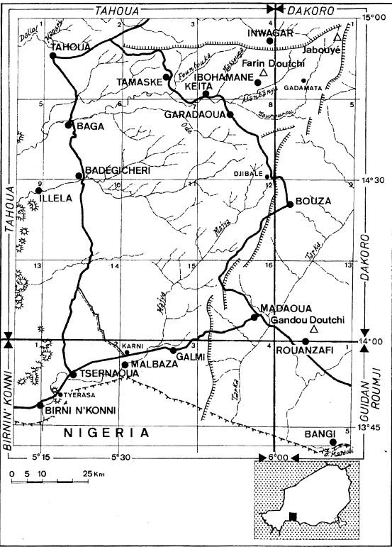
No ideal type section could be located. Greigert et al. (1966) based their description on sections from wells. Dubois (1979) described in detail several sections of which the most representative is located in Djibale (Fig. 1 & Fig. 4).
[Figure: 1 Location Map of Ader Doutchi Fm]
References: Pougnet, 1949; Greigert, 1966; Dubois, 1979; Boudouresque et al., 1982; Fabre et al., 1983; Dubois et al., 1984; Bellion, 1987; Lang et al., 1986, 1990; Hanon, 1990; Dikouma, 1990, 1994; Dikouma et al., 1993, 1994; Tintant et al., 2001; Beauvais et al., 2008; Moumouni et al., 2019; Heckmann, 2019; Ousmane et al., 2020; Laouali-Idi et al., 2019, 2021.
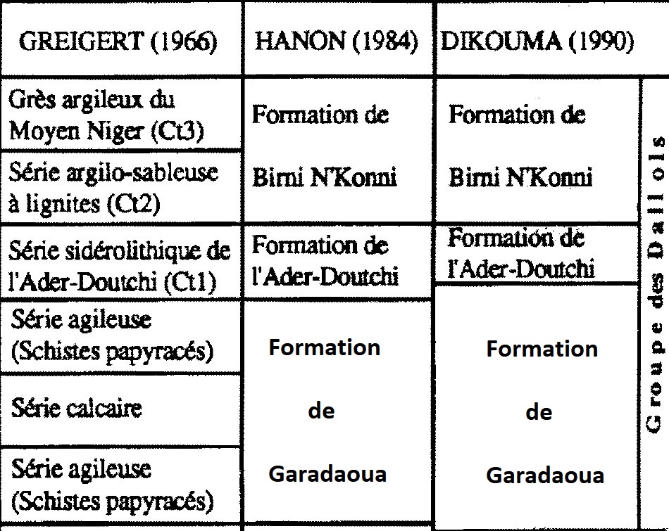
Synonym: Série sidérolithique de l’Ader Doutchi (Greigert (1966)); Série de l’Ader Doutchi (Fig. 2). Adar Doutchi (misspelling). In his "Kandi Fm" (which is supposed to be Ordovician, as per its description in Benin), Pougnet (1949) finds silicified wood near the town of Gaya. Since wood/plants did not yet exist during the Ordovician, it can only be the Ader Doutchi Fm which contains wood similar to the specimens encountered by Pougnet; Equivalent(s): Continental Terminal 1 (or Ct1) at the base of the Continental Terminal (Greigert (1966));
[Figure 2: Synonyms of Ader Doutchi Fm]
Lithology and Thickness
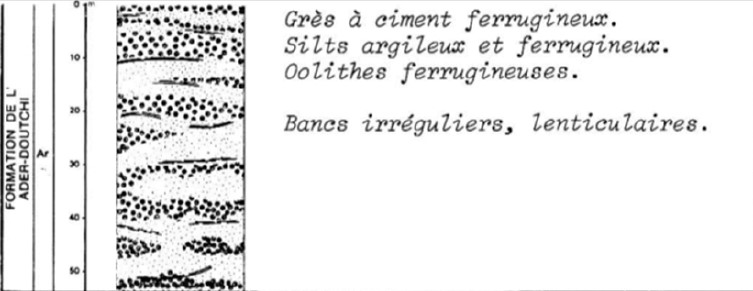
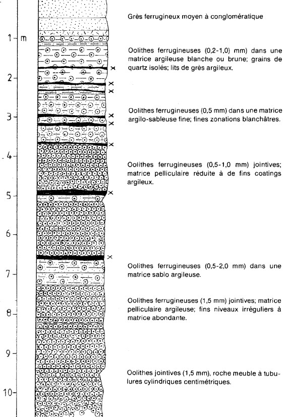
It consists mainly of variegated argillites and argillaceous siltstones at the base. The Ader Doutchi Formation alternates irregular beds, made up of kaolinitic clays, more or less lateritic, and ferruginous ooliths in its middle part. The top of this formation consists of sandstone with ferruginous oolites (Fig. 3). Hannon (1990) describes it as follows (Fig. 4):
Set of ferruginous rocks; alternating decimetric to metric layers, of irregular thickness, lenticular; rocks often hardened, of dark shades, black, brown, red, purplish:
- Fine to coarse-grained quartz sand and sand, usually angular, ferruginous cement, clayey and ferruginous or absent; ferruginous oolites in various proportions; oblique stratifications.
- Conglomerates with angular quartz gravel generally less than 1 cm locally containing schist pebbles; ferruginous, clayey, or siliceous matrix.
- Goethite oolites; diameter between 0.1 mm and 3 mm; free, contiguous, or cemented by silty, clayey, ferruginous matrices in various proportions.
- Gray clays and silts are often hard and rubefied and may contain ferruginous oolites.
Thickness: 430 m (Laouali-Idi, 2021). In the west of the Ader Doutchi region, where it is overlayed by the Birni N'Konni Formation, the formation presents a gradually increasing thickness from south to north: from about 25 m in the region of Malbaza-Tsernaoua to about 45 m in Tahoua. In the northwest (Keita, Ibohamane), where the upper contact is eroded, it reaches a thickness of 55 m (Hanon, 1990).
[Figure 3: Lithology of Ader Doutchi Fm]
[Figure 4: Lithostratigraphic Column of Ader Doutchi Fm]
Relationships and Distribution
Lower contact
Rests in discordance either on the Garadaoua Fm, Precambrian basement or the continental Mesozoic
Upper contact
Overlying unit is the Birni N’Konni Fm, when present
Regional extent
Iullemmeden Basin
GeoJSON
Fossils
Flora consisting of Echiperiporites icacinoides, Cicatricosisporites dorogensis, Chenolophonidites costatus, Striatapollis bellus and Bombacacidites sp., suggesting the proximity of savannah conditions.
Age
Depositional setting
Shallow and rough epicontinental sea, close to estuaries or deltas responsible for the iron supply. This was proposed by Faure (1966), who attributed the oolitic deposits to sedimentation of a "disappearing sea" within the framework of an advanced phase of filling the Iullemmeden Basin.
Additional Information
The formation belongs to the Continental terminal was considered by Faure (1966) with reservations. For Dubois and Lang (1984), this ferruginous set constitutes the final phase of the marine sedimentary cycle; these authors suggest the existence, at the top of the cycle thus defined, of a major cut probably corresponding to a sedimentation gap and exclude it from the Continental terminal (Hanon (1990)).